 | |
Project Overview | Project Code: ED 06 |
|---|---|
| Project name: | Land water and forest change in New Capital of Indonesia |
| TUM Department: | ED - Aerospace and Geodesy |
| TUM Chair / Institute: | Land management |
| Research area: | Land management |
| Student background: | Aerospace / Geodesy |
| Further disciplines: | |
Planned project location: | Arcisstrasse 21, Munich |
Project Supervisor - Contact Details | |
|---|---|
| Title: | Prof. Dr. |
| Given name: | Walter Timo |
| Family name: | de Vries |
| E-mail: | wt.de-vries@tum.de |
| Phone: | +49 89 289 25799 |
Additional Project Supervisor - Contact Details | |
|---|---|
| Title: | Mr. |
| Given name: | Achmad |
| Family name: | Ghozali |
| E-mail: | ge62kac@mytum.de |
| Phone: |
Additional Project Supervisor - Contact Details | |
|---|---|
| Title: | |
| Given name: | |
| Family name: | |
| E-mail: | |
| Phone: |
Project Description | |
|---|---|
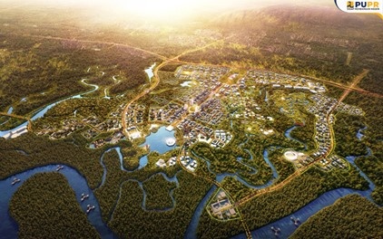
| Project description: | Indonesia decided to create a new capital city on the Island of Borneo, Nusantara, in between the cities of Balikpapan and Samarinda, and in the vicinity of one of the largest tropical forests of the world. Effecting this decision will not only change the land use of the designated capital city area / territory, but will also change the surrounding areas. Most notably, the capital city requires land for residential areas, office buildings, transportation and green areas, amongst others and a good functioning water system for providing drinking water, waste water facilities, drainage of rainwater, etc. Although the basic design of the new capital city has been completed, a new city tends to develop in multiple ways. How a city grows and develops for different socio-spatial developments needs to be simulated in multiple scenarios, in order to assess the possible effects and impacts on land, water and forest. These simulations rely on both geospatial and statistical data, combined with various government policy documents and strategies. These data are partly available yet in different formats and from different spatial and temporal qualities. The aim of this practical internship is to synthesize the available datasets for one or more domains (i.e. land, water, forests) and to design one or more socio-spatial and/or biophysical scenarios for future developments and impacts. This will be done with the use of Geographic information systems, remote sensing and the use of statistical software. |
| Working hours per week planned: | 30 |
Prerequisites | |
|---|---|
Required study level minimum (at time of TUM PREP project start): | 3 years of bachelor studies completed |
| Subject related: | land management, geodesy, geoinfomatics, civil engineering |
| Other: | environmental engineering, water management |